Excelsior Correspondent
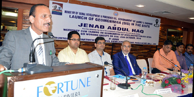
JAMMU, Oct 25: Geo-tagging of assets under MGNREGA is a touchstone of transparency that will enforce better monitoring, recording and management of developmental works at the cutting edge level.
This was stated by the Minister for Rural Development and Panchayati Raj, Abdul Haq after launching Geo-MGNREGA (GIS) during a workshop here today.
Director MGNREGA, Union Ministry of Rural Development, Kaushal Pathak, Secretary RDD and Panchayati Raj, Kifayat Hussain Rizvi, Deputy Commissioner Udhampur, Rajouri, Poonch, Reasi and Director RDD Jammu and Director RDD Kashmir and other senior officers of the department were present on the occasion.
The Minister said technological intervention is a paradigm shift in infusing the much required transparency in the system and easing out monitoring process at the micro-level.
He said MGNREGA is a vital scheme for rural development in terms of infrastructure development and generation of employment avenues that makes it imperative for all the stakeholders to implement it on a mission mode to achieve the envisaged goals.
He said technology is an empowering tool for citizens and a medium of ensuring accountability, adding that this major initiative will make use of GIS solutions to visualize, analyze and explore such assets related data and also manage them more efficiently along with better understanding of their outcomes.
Abdul Haq said transparency, accountability and zero tolerance for corruption continues to be the hallmark of present dispensation and both the Central and State Governments are working on an agenda of providing good governance to the people.
Highlighting the steps underway in the RDD sector in the State under MGNREGA, the Minister said the department is focusing on creating tangible assets on ground which have wide public utility.
“The convergence mode under which the projects of various departments were dovetailed with MGNREGA have helped in better micro-level development,” said the Minister stressing that MGNREGA should be implemented on a mission mode for achieving optimal results.
Pertinent to mention here that MGNREGA GIS Solution intends to provide a single and integrated view of asset information system pan rural India. GIS enabled portal (e-Governance) will act as a gateway to facilitate and coordinate the exchange and sharing of geospatial data between stakeholders from various jurisdictional levels in the spatial data Community.
This will facilitate to search, locate and publish geospatial data wherein end users can access, share and publish (with appropriate log-in authenticity) in response to the needs of diverse laser groups. The GIS enabled portal will maintain, process, store, distribute and improve the utilization of geospatial-data for planners, decision makers and public. This will help the Department in possessing a valuable digital database (both spatial and non-spatial and non-spatial) for the entire country.
Trending Now
E-Paper


