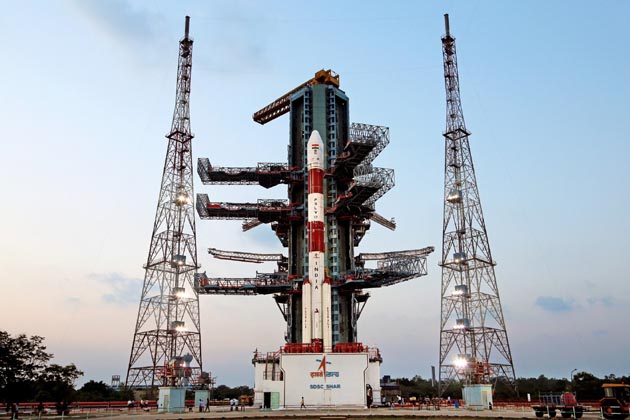
CHENNAI: The 51.5 hour countdown for the launch of India’s seventh and final navigation satellite IRNSS-1G by the workhorse launch vehicle PSLV-C33 commenced at 0920 hrs at the Satish Dhawan Space Centre, SHAR Range, Sriharikota, about 80 km from here, this morning.
Indian Space Research Organisation (ISRO) sources said that the 1,425 kg satellite, which would complete the constellation of seven satellites as part of the Indian Regional Navigation Satellite System (IRNSS) on par with the Global Positioning System (GPS) of the US, would be launched from the First Launch Pad at 1250 hrs on April 28.
The sources said the Mission Readiness Review (MRR) committee and the Launch Authorisation Board (LAB) has cleared the 51.5 hr countdown starting at 0920 hrs today and the launch of PSLV-C33 /IRNSS-1G Mission.
Following this, the countdown process began this morning.
During the countdown, propellant filling operations would be carried out in the four-stage vehicle, the sources said. About 20 minutes after lift off, the Polar Satellite Launch Vehicle, in its 35th flight will inject IRNSS-1G into a Sub-Geosynchronous Transfer Orbit (Sub-GTO) with a 284 km perigee (nearest point to earth) and 20,657 km apogee (farthest point to earth) with an inclination of 17.86 deg with respect to the equatorial plane.
As in the previous six launches of IRNSS satellites, PSLV-C33 will use ‘XL’ version of PSLV equipped with six strap-ons, each carrying 12 tons of propellant.
This would be for the 13th time ‘XL’ configuration would be flown, the earlier 12 occasions being PSLV-C11/Chandrayaan-1, PSLV-C17/GSAT-12, PSLV-C19/RISAT-1, PSLV-C22/IRNSS-1A, PSLV-C25/Mars Orbiter Spacecraft, PSLV-C24/IRNSS-1B, PSLV-C26/IRNSS-1C, PSLV-C27/IRNSS-1D, PSLV-C28/DMC-3, PSLV-C30/ASTROSAT, PSLV-C31/ IRNSS-IE and PSLV-C32/IRNSS-1F missions.
IRNSS-1G’s predecessors, IRNSS-1A, 1B, 1C, 1D, 1E and 1F were launched by PSLV-C22, PSLV-C24, PSLV-C26, PSLV-C27, PSLV-C31 and PSLV-C32 in July 2013, April 2014, October 2014, March 2015, January and March 2016 respectively.
With this launch, India would be joining the elite group of nations to have its own regional satellite navigation system, on par with the GPS system of the United States (US).
The launch of the last and seventh satellite IRNSS-1G, would mark the completion of the entire Phase-1 IRNSS constellation.
Till date, India has launched six regional navigational satellites (IRNSS-1A, 1B, 1C, ID, 1E and 1F) as part of a constellation of seven satellites to provide accurate position information service to users across the country and the region, extending up to an area of 1,500 km.
The configuration of IRNSS-1G would be similar to that of IRNSS-1A, 1B, 1C 1D, 1E and 1F.
The IRNSS was similar to the Global Positioning System (GPS) of the US (24 satellites), Glonass of Russia, and Galileo of Europe as well as China’s Beidou.
The Indian Regional Navigation Spacecraft System (IRNSS) is the Indian navigation system which envisages establishment of regional navigation system using a combination of GEO and GSO spacecraft. IRNSS system would provide position accuracy of better than 20 m over Indian region and an area extending about 1500 sq km around India.
IRNSS constellation consists of three Geostationary Earth Orbit (GEO) spacecraft and four spacecraft in Geosynchronous orbit inclined at 29 deg.
It would provide two types of services, namely, Standard Positioning Services (SPS), provided to all users, and Restricted Services (RS), provided to authorized users.
With the operationalisation of six satellites, proof-of-concept of an independent regional navigation satellite system over India has been demonstrated for the targeted position accuracy, which is much better than 20 mtrs over 24 hours of the day.
With the launch and operationalisation of IRNSS-1G, the seventh in the constellation, the completion of IRNSS constellation would be achieved.
(AGENCIES)


