Dr. Mansoor Ahmad Qazi
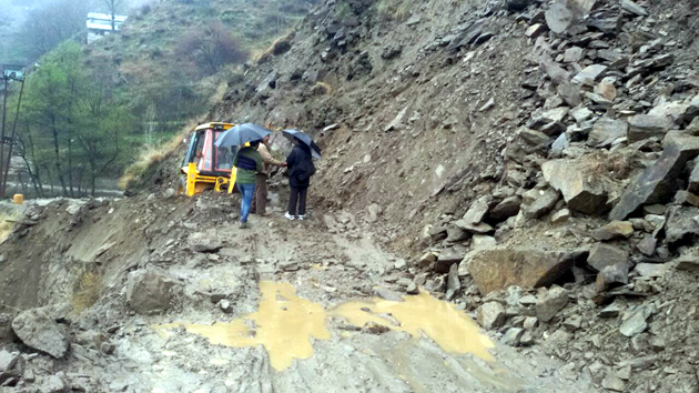
The Batote-Kishtwar National Highway is on the verge of collapse. Several places which experience heavy ingress of water come down frequently from the hills, which causes road obstruction for days. At different locations all along the highway, deep as well as wide cracks are observed which are on a high risk as far as transportation is concerned. The cracks on the hill slopes are attributed to landslides of different types, caused by over saturation and reduced shear strength of the slope-forming material, combined with an increase of shear stresses due to removal of toe support. Heaps of debris are found all along the highway, which also causes obstruction to the movement of vehicles.
Two major agencies which destroy the highway along the Batote-Kishtwar are BSNL and GREF. The BSNL excavated trenches for underground cables and GREF excavated along the hill side for widening of the road and left the toe of the hillocks unsupported. It is observed that the BSNL after excavation lay down the cables and fills the excavated trenches with the loose material without any compaction and treatment on the upper surface. When rainwater and the water coming from the hills percolates into the ordinary filled trenches, it leaches out all the fine material and ultimately the ground as well as the slope become weak and sliding and cracking starts all along the roads. The road slip is frequently observed all along the said national highway. Mostly the failure of the roads occurs along the excavated trenches meant for the underground cables by the BSNL. The BSNL should take the sole responsibility to undertake the sliding issues and make sure to completely treat the excavated trenches with the modern technologies after consultation of the technical experts. The administration should take up the matter seriously in a proper way by means of technical committees and monitoring.
The GREF excavated all along the said national highway for widening of the road. Although the widening on most of the part has been completed, but no immediate toe support has been provided to control the movement of the hill. Technically, it is a wrong tactic to excavate along the hills and leave the toe unsupported. Without toe support, the hillock becomes unstable and sliding starts. Now the administration should take immediate action to properly support the excavated areas so that further sliding along the highway should be prevented.
The weather material jointed or fissured materials, contrast in permeability, erosion of slope toe and intense rainfalls are the other causes of the landslides. It is also observed all along the said highway that the previous slide materials are not cleared from the roads, because of non availability of the manpower and machinery setup with the government departments. Some training and preparedness/awareness programs are to be carried out by the administrations about the landslides, as landslides constitute major hazards in our state. These landslides account for considerable loss of life and damage to communication, agriculture fields and forest lands. The landslide hazard zonation map of India needs to be popularized among the architects, engineers and development planners and also to public so that it is used as a tool for regulating construction or development activities and means of managing or mitigating landslide disasters. As the landslides destroy anything that comes in their path, they block or bury roads, lines of communication, settlements, river flow, agriculture land etc.
Recommendations have been made for controlling the slides on the basis of the recognition of the factors contributing to the slides and the type of the slides. These measures comprise removal of loose blocks; flattening of slopes; interception of slopes by benching subsurface drainage by trenches and drill hole; consolidation of the slopes from erosion by means of retaining structures.
Mitigation Strategies:
* Areas prone to slope failures shall be avoided for building settlements.
* Areas covered by degraded natural vegetation in upper slopes are to be afforested with suitable species.
* Any development activity initiated in the area should be taken up only after a detailed study of the region is done and slope protection should be carried out if necessary without any delay.
* In construction of roads, irrigation canals etc. proper care should be taken to avoid blockage of natural drainage.
* Total avoidance of settlements in the risk zone should be made mandatory.
* Relocate settlements and infrastructure that fall in the possible path of the landslides.
* No construction of buildings in areas beyond a certain degree of slope.
* Toe support by means of retaining walls should be provided at an earliest after the excavation has been completed along a hill with proper design. Reconstructing the retaining wall on bedrock on removal of the hump.
* Construction of masonry buttress-walls all along the road on the hill-side and scaling of loose blocks of rock.
* The surface drainage control works are to be implemented to control the movement of the landslides accompanied by infiltration of rain water and spring flows. Provision of drilled drainage holes driven at different angles so as to intersect the open joint planes. The holes should be taken 15 m. into rock. The drainage from these holes should be collected through hose-pipe and lead into a drain at road level.
* Increase the vegetation cover, as it is the cheapest and most effective way of arresting the landslides.
(The author is an Engineering Geologist, Chenab Valley Power Project Limited)
Trending Now
E-Paper


