Excelsior Correspondent
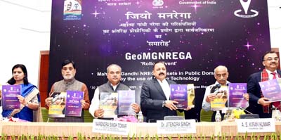
NEW DELHI, Nov 30: In a historic and a path-breaking new initiative, the Modi Government today launched the, first of its kind, “Geo MGNREGA (Mahatma Gandhi National Rural Employment Guarantee Act)” involving Space technology for monitoring, measuring and reporting the progress and status of works as well as assets under the MGNREGA national programme.
The formal launching was done jointly by Union Minister for Rural Development, Narendra Singh Tomar and Union Minister for Department of Space, Dr Jitendra Singh. The Standard Operating Manual book for “Geo MGNREGA” was also released by the two Ministers.
Speaking on the occasion, Union Rural Development Minister Narendra Singh Tomar welcomed the joint initiative between his Ministry and the Department of Space. He said, this will not only help in better accomplishments under the MGNREGA but will also help in expediting and regularly monitoring them.
Tomar said,the new arrangement between the two Ministries will also bring in transparency both in monitoring of MGNREGA works as well as in disbursing of the MGNREGA assets to the rightful individuals. In this context, he disclosed that 568943 assets geo-tagged as on November 28, 2016 will also go public and become accessible.
Dr Jitendra Singh, in his address, said that even though India’s Space programme was initiated by Vikram Sarabhai and his colleagues over half-a-century ago, it is actually the present government under the visionary leadership of Prime Minister Narendra Modi which has truly vindicated the dream of the founding fathers by introducing the applications of Space technology in different fields and truly making India’s Space programme an adjuvant for development and growth of common citizens of India. Whereas earlier, Indian Space Research Organization (ISRO) was only in news whenever a rocket was launched from Sriharikota, but in the last two years, he said, we have succeeded in showing the world how with the help of Satellite imaging, remote sensing and Space technology it is possible to fast-track the citizen-oriented works in urban and rural development, construction of buildings and roads, surveys for new projects, in addition to disaster management and accurate weather forecast.
Dr Jitendra Singh disclosed that the “Smart City” programme taken up by the Modi Government is also going to use this Space technology in a big way.
As for GeoMGNREGA, Dr Jitendra Singh said, use of Space technology will not only help bring in greater transparency, but will also ensure authenticity by procuring accurate images and pictures of the spots on the ground where MGNREGA work is in progress. He said, the same technology can also be applied for verifying and preparing authentic Utilization Certificates (UCs) and DPRs for various projects and he has already started this experiment in the Northeast under the Ministry of DoNER.
There has often been complaints of pilferage and embezzlement of payments and funds disbursed under MGNREGA, said Dr Jitendra Singh, and added that the introduction of hi-tech Space technology with the geo tagging of the assets will ensure that each payment is made to the individual asset for which it is meant and will eliminate the role of middlemen and corrupt officials. This will also be in tune with the Modi Govt’s current drive for “cashless” payments,he added.The geo-tagging of MGNREGA, he said, will also leave no room for the opening of so called “ghost accounts” by embezzlers or corrupt functionaries.
MoS Rural Development Ram Kripal Yadav and Chairman ISRO Kiran Kumar also spoke on the occasion. Certificates were also distributed to Geo MGNREGA resource persons.

