CHENNAI, Mar 8:
NISAR, a Joint Earth Observation Satellite between ISRO and NASA, landed in Bengaluru airport for further tests and for integrating into the Launch vehicle for proposed launch in January 2024 from the spaceport of Sriharikota.
After a 9,000 mile (14,000 km long) journey the US Airforce C-17 aircraft carrying the satellite, touched down at the Bengaluru airport today.
US Consulate General Chennai today tweeted “touchdown in Bengaluru! @ISRO receives NISAR (@NASA-ISRO Synthetic Aperture Radar) on a USAirforce C-17 from @NASAJPL in California, setting the stage for final integration of the Earth observation satellite, a true symbol of #USIndia civil space collaboration. #USIndiaTogether”.
In the tweet, the US Consulate Chennai also tagged photos of the airport upon its landing in Bengaluru airport.
NISAR is one of the biggest project being collaborated with between the US Space Agency the National Aeronautics and Space Administration (NASA) and the Indian Space Research Organisation (ISRO).
ISRO sources said NISAR mission will be “a game-changer” in terms of research and applications and throw open a very novel way of looking at earth from space.
Earlier, The NISAR satellite was accorded a traditional South Indian style send off ceremony by breaking coconuts last month.
Officials from NASA, ISRO, Jet Propulsion Laboratory (JPL) and the Indian Embassy held a send-off ceremony before the NASA-ISRO Synthetic Aperture Radar (NISAR) science instrument payload was transported to southern India for integration with the spacecraft bus, for further testing and launch in 2024.
On February five, NISAR, the SUV-size payload was loaded into a special cargo container for a 9,000 mile (14,000 km) flight journey to India’s U R Rao Satellite Centre in Bengaluru, where it will be merged with the spacecraft bus in preparation for a 2024 launch from the Satish Dhawan Space Centre.
NISAR is a joint Earth-observing mission between NASA and ISRO.
Before its departure, NISAR’s advanced radar instruments were shown to the media in the clean room at NASA’s JPL in Southern California in the presence of ISRO Chairman S.Somanath, JPL Director Laurie Leshin, and dignitaries from NASA headquarters and India, and members of the mission team.
Outside the facility, in front of a scale model of the NISAR satellite, NASA’s NISAR Project Manager Phil Barela and ISRO’s NISAR Project Director CV Shrikant ceremonially broke fresh coconuts.
The tradition, common in India, especially in South India, often marks auspicious occasions and signifies hope for a smooth road ahead.
Leshin also presented a jar of JPL lucky peanuts to the ISRO delegation
“This marks an important milestone in our shared journey to better understand planet Earth and our changing climate,” Leshin said.
“NISAR will provide critical information on Earth’s crust, ice sheets and ecosystems. By delivering measurements at unprecedented precision, NISAR’s promise is new understanding and positive impact in communities. Our collaboration with ISRO exemplifies what’s possible when we tackle complex challenges together”, he said.
The ISRO Chairman said “Today we come one step closer to fulfilling the immense scientific potential NASA and ISRO envisioned for NISAR when we joined forces more than eight years ago.”
Somanath said “this mission will be a powerful demonstration of the capability of radar as a science tool and help us study Earth’s dynamic land and ice surfaces in greater detail than ever before”.
The NASA-ISRO SAR Mission (NISAR), a joint Earth-observing mission, is one of the biggest project being collaborated with between the US Space Agency the National Aeronautics and Space Administration (NASA) and ISRO.
The launch of NISAR mission will be in early 2024, probably in January, from the SHAR Range, Sriharikota, and it will injected into a near-polar orbit at an altitude of 747 km with an inclination of 98.4 deg.
ISRO will be using its heaviest home grown rocket GSLV-MkII/LVM-3 for the mission which will take place from the Second Launch Pad, according to information collected from the NASA website on the NISAR mission.
The NISAR Mission will measure Earth’s changing ecosystems, dynamic surfaces, and ice masses providing information about biomass, natural hazards, sea level rise, and groundwater, and will support a host of other applications.
NISAR will observe Earth’s land and ice-covered surfaces globally with 12-day regularity on ascending and descending passes, sampling Earth on average every 6 days for a baseline 3-year mission.
NISAR will map global land biomass, the amount of organic material from plants, every 12 days.
NISAR is the first satellite mission to collect radar data in two microwave bandwidth regions, called the L-band and the S-band, to measure changes in our planet’s surface less than a centimeter across.
This allows the mission to observe a wide range of Earth processes, from the flow rates of glaciers and ice sheets to the dynamics of earthquakes and volcanoes.
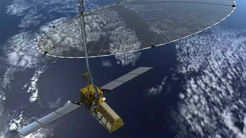
NISAR uses a sophisticated information-processing technique known as Synthetic Aperture Radar (SAR) to produce extremely high resolution images.
The Radar penetrates clouds and darkness, enabling NISAR to collect data day and night in any weather. The instrument’s imaging swath – the width of the strip of data collected along the length of the orbit track – is greater than 150 miles (240 kilometers), which allows it to image the entire Earth in 12 days.
Over the course of multiple orbits, the radar images will allow users to track changes in croplands and hazard sites, as well as to monitor ongoing crises such as volcanic eruptions.
The images will be detailed enough to show local changes and broad enough to measure regional trends.
As the mission continues for years, the data will allow for better understanding of the causes and consequences of land surface changes, increasing our ability to manage resources and prepare for and cope with global change.
(UNI)