Sumit Johar, Prof. S.K. Pandita
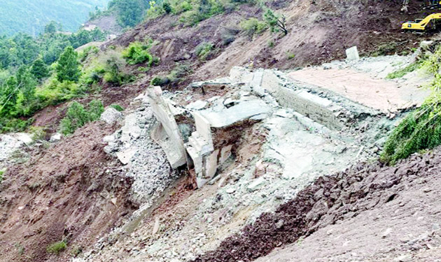
The Union Territory of Jammu and Kashmir is vulnerable to landslides due to its diverse topography, geological conditions, heavy rainfall, and anthropogenic activities. Landslides occur due to geological factors such as slope steepness and rock properties, climatic factors such as heavy rainfall during the monsoon season, and anthropogenic factors like deforestation, urbanization, and improper land use practices. The impacts of landslides are severe and wide-ranging, resulting in loss of lives, injuries, and displacement of communities. Landslides also damage infrastructure, disrupt transportation networks, and hinder economic activities. They also have environmental consequences such as the loss of natural vegetation, soil quality degradation, and watercourses alteration. Flooding caused by blocked rivers and increased sedimentation affects water quality and availability. Socioeconomic impacts include limited access to essential services, loss of agricultural land, and the economic burden of recovery and rehabilitation efforts.
Land cover changes such as deforestation and loss of vegetation cover directly influence landslide susceptibility. Forests play a crucial role in stabilizing slopes by absorbing rainfall, reducing surface runoff, and maintaining soil cohesion. Deforestation for timber extraction, agriculture, and urbanization increases landslide risks. Urbanization and infrastructure development disrupt natural drainage patterns, add pressure on slopes, and destabilize the land. Unsustainable agricultural practices such as cultivation on steep slopes contribute to soil erosion and landslide occurrences. Inadequate land use planning and regulation enforcement exacerbate landslide risks in Jammu and Kashmir. Unsustainable practices including unregulated mining, quarrying, and hill cutting weaken slope stability. Encroachment in high-risk areas exposes communities to landslide hazards. Improper zoning regulations and weak enforcement of building codes contribute to landslide risks. Comprehensive land use planning that considers the geological and hydrological characteristics of the region is essential to minimize landslide vulnerabilities.
The region’s diverse geology, hilly topography, and location in seismic zones 4 and 5, make slope stability a significant concern. Among the vulnerable areas prone to landslides, the National Highway (NH-44) serves as the sole all-weather road connecting to the Kashmir valley. Currently, NH-44 faces a considerable challenge with over 40 active small and large landslides such as Toldi Slide, Dewal Bridge Site, Daramthal Site, Chenani, and Ramban Slide etc…Additionally, there are two major landslides occurring along the Bani-Basholi road in the Kathua district of Jammu and Kashmir. One of these landslides is in the vicinity of Kardoo Village, while the other one is the Sukha Nala landslide. During rainy periods, these sites experience the accumulation of scree material and boulders on the road, leading to significant loss of life, property and traffic disruptions between the Bani and Basholi National Highway.
One of the prominent natural disasters, the Sadal landslide of 2014 had devastating effects in Jammu, resulting in significant loss of life and property. The persistent rainfall from September 2 to September 6, 2014, triggered a large landslide at the village Sadal in Jammu and Kashmir’s Udhampur district. The landslide happened early on September 6, 2014, devastating the whole Sadal population of 45 residences, and killing 41 people and over 500 household animals. The horizontal and vertical components of displacement, as well as the method of failure, indicate that the landslide is of a complex nature. Recently, On 19 July 2023, landslides occurred in the vicinity of Surjan village of Bani tehsil of Kathua district, leading to the loss of 8 people’s lives.
To mitigate the impacts of landslides, various strategies can be implemented. Early warning systems that utilize monitoring technologies can detect changes in slope stability and issue timely alerts to vulnerable communities. Ecosystem-based approaches such as reforestation and habitat restoration can enhance slope stability and reduce landslide risks. Sustainable land use planning including proper zoning regulations, building codes, and land management practices is crucial. Strict enforcement of regulations and guidelines ensures responsible land use practices.
In conclusion, landslides, land cover changes, and land use patterns have profound impacts on India. Addressing landslide vulnerabilities requires effective land management strategies. Sustainable land use planning, ecosystem-based approaches, and early warning systems are essential for mitigating the adverse impacts of landslides. The case studies emphasize the importance of considering geological, climatic, and anthropogenic factors in landslide risk assessment and disaster management. By implementing these strategies, Jammu and Kashmir can enhance resilience, protect lives and livelihoods, and promote sustainable development in landslide-prone regions. Further research and monitoring efforts are necessary to improve understanding and develop effective mitigation and adaptation measures.
(The authors are from Department of Geology University of Jammu)
Trending Now
E-Paper


